
Google Maps introduced mass transit crowdedness predictions back in June 2019. The feature provided commuters with valuable information about how crowded a bus, train, or tube would be before they got on it, helping them plan their daily commute accordingly. At first, the feature was available in 200 cities worldwide, but Google is now expanding it to “over 10,000 transit agencies in 100 countries.”
In a blog post regarding the expansion, Google wrote:
“It’s no surprise that transit ridership took a drastic plunge during the early days of the pandemic. While people are returning to public transit — with transit directions on Maps increasing 50% compared to last year in the U.S. — safety remains top of mind. That’s why we’re expanding transit crowdedness predictions to over 10,000 transit agencies in 100 countries so you’ll know if your line is likely to have lots of open seats, hit full capacity, or be anywhere in between. With this information you can decide whether you want to hop on board or wait for another train. Because pandemic or not, no one likes standing in a jam-packed subway car. “
The feature makes use of historical location data and self-reporting from Maps users to generate these predictions. All location data used for the feature is anonymized.
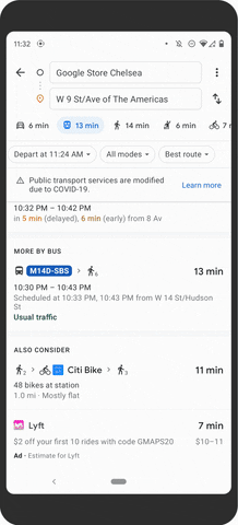
Transit crowdedness predictions
Along with the expansion, Google is piloting the ability to see live crowdedness information down to the transit car level in New York and Sydney (via The Verge). This feature will provide users with more granular information, like the crowdedness of a particular train car instead of the entire train in general. Unlike the regular crowdedness predictions, Google uses data provided by transit agencies to generate these granular predictions. After testing the feature in these two cities, Google plans to roll it out to more cities soon.

Train level crowdedness predictions
Furthermore, Google is also adding a few new features to the Maps Timeline on Android. These include a new “Insights” tab that shows trends about the amount of time you’ve spent and the distance you’ve traveled in different transport methods. It also shows the places you’ve visited.
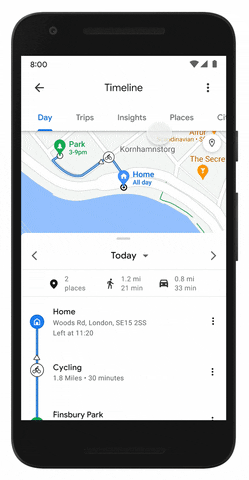
New Timeline Insights
Google Maps now also has a “Trips” tab that lists all locations visited and gives users the option to export the list to share it with others.

New restaurant review prompts
Lastly, Google Maps will also offer additional review options for restaurants in the US, with new prompts to share meal pricing, takeout and delivery availability, and more. Google plans to offer similar prompts for other businesses soon.
The post Google Maps is expanding its mass transit crowdedness predictions appeared first on xda-developers.
from xda-developers https://ift.tt/3BtvIwA
via IFTTT
Aucun commentaire:
Enregistrer un commentaire